The provided diagrams show the expansion of a subway system from 1990 to 2010.
Summarize the information by selecting and reporting the main features, and make comparisons where relevant.
Write at least 150 words.
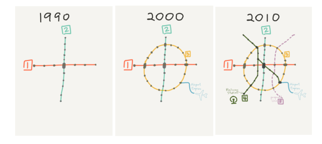
The three diagrams depict the expansion of a subway system at ten year intervals from 1990 to 2010. The maps show how the system expanded from just two lines in 1990 to incorporating 5 full lines, an airport express, and a further proposed line 20 years later.
Looking at the difference at each ten year point in more detail, it is possible to see how the expansion unfurled. Whereas the 1990 map shows just two lines (the east-west Line 1, and the north-south Line 2), the 2000 version shows these original services have been complemented with two additional routes: Line 3, which circumnavigates the area, and an airport express which branches off the new Line 3 in the south-east. This four line 2000 network is then upgraded further, so that by 2010 a new Line 4 has been added north-to-south on the west side of the city, twice intersecting the circular Line 3 and terminating at the railway station in the south-west, as well as a Line 5 that runs diagonally from its connection to Line 4 in the north-west to meet Line 3 and the Airport Express in the south-east. On top of this, a new proposed track is included on the final map: Line 6 will almost mirror the path taken by Line 4, but down the east side of the city rather than the west. This would complete the twenty year overhaul of the subway system described by the 3 maps.